views
After four months of rain, the southwest monsoon has begun its retreat from West Rajasthan a week later than usual, said the India Meteorological Department (IMD) on Monday. The withdrawal has also begun from Kachchh region of Gujarat.
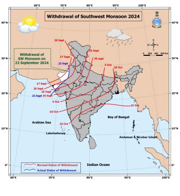
Usually, the monsoon retreat starts from Bikaner and Jaisalmer districts by September 17, however, this time, the seasonal rain continued through the week. In fact, the rainy system has been taking a little longer to retreat from this region over the years – a long-term trend confirmed by meteorologists.
Last year, the monsoon retreat began from West Rajasthan on September 25 – eight days later than its normal date of September 17. In 2022, it was late by three days (September 20), but a year before it did not start withdrawing until October 6 – a delay of over three weeks. In Delhi, the rains normally end by September 25.
The line of withdrawal currently passes through Rajasthan’s Anupgarh, Bikaner, Jodhpur and Gujarat’s Bhuj and Dwarka districts. According to IMD, the conditions are favourable for its further withdrawal from some more parts of West Rajasthan and adjoining areas of Punjab, Haryana and Gujarat during the next 24 hours. The weather is likely to mostly remain dry over Northwest India, except for some scattered showers in some areas over the next few days.
This is crucial, considering the harvesting season is all set to begin across states in Northwest India, where farmers are preparing to reap major crops like paddy. So far, the monsoon has been 6% above normal over Northwest India, 16-15% over Central and southern peninsular, while it is (-16%) deficient in North-east India.

Overall, the monsoon is 5% above the long-term average. Of the total 36 sub-divisions, 9 subdivisions mostly along the west-coast have recorded excess rains, including Rajasthan (74%), Gujarat (68%), Maharashtra, Tamil Nadu and coastal Andhra Pradesh. The rainfall has been below-normal in Jammu and Kashmir (-25%), Punjab (-27%), Himachal Pradesh (-20%), Bihar (-28%) and Arunachal Pradesh (-29%).
Back-to-back low pressure systems have formed all through the month, bringing continuous rains over major parts of India. IMD’s latest forecast also suggests another low-pressure area is likely to form over west-central Bay of Bengal by Tuesday, which will trigger fairly widespread rains over coastal Karnataka, Andhra Pradesh, Rayalaseema, and also Tamil Nadu this week.
The forecast also indicated the likelihood of isolated heavy rainfall over Uttarakhand on September 25 and 26, as well as East Uttar Pradesh on September 26-27. The IMD has forecast above-normal rain for the month.
The four-month monsoon usually withdraws from entire India by October 15, setting the stage for the arrival of another major rainy-system – North-east Monsoon, which mainly brings rain over southern India from October to December.


Comments
0 comment