views
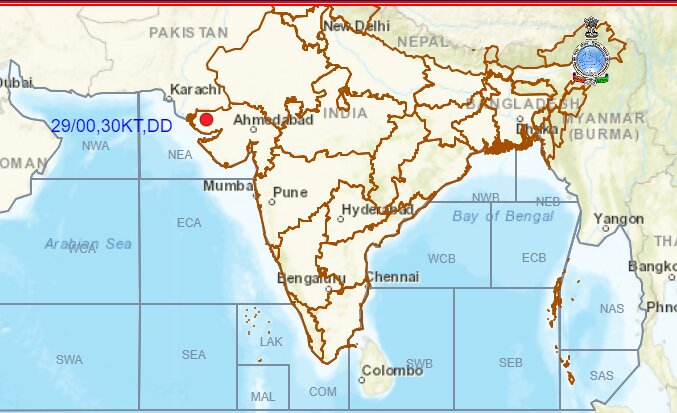
Hit by torrential monsoon rains, flood-hit Gujarat is now bracing for a cyclone which is set to form on the adjoining Kachchh-Pakistan coast on Friday, in what scientists have described as a ‘rare’ event. However, once it develops, the cyclone will start moving away from the coast into the Arabian Sea and eventually dissipate.
The tropical cyclones usually form in the Bay of Bengal and Arabian Sea during the pre-monsoon season (March-April-May) or post-monsoon season (October-November-December). But the yet-to-be-formed cyclonic storm had its genesis over the land where it intensified and then moved westwards towards the coast.
According to meteorologists, it is not usual for cyclones to form during the southwest monsoon from June to September. “It can happen, but it is very rare. There have been a few instances in the past. Though its genesis was over the land, it was fuelled by high moisture incursion from the Arabian Sea. But once it forms, the cyclone may not be very strong,” said senior IMD scientist Monika Sharma.
FROM THE LAND TO THE SEA
The cyclonic disturbance was first reported as a ‘low pressure area’ on August 24, which became ‘well-marked’ and intensified into a ‘depression’ over Madhya Pradesh on August 25. It further gained strength and turned into a ‘deep depression’ by midnight as it moved towards Rajasthan and Gujarat. These scientific terms are used to characterise subsequent stages of a cyclone formation, depending on the maximum surface winds.

A tropical cyclone is formed due to an instability in the atmosphere around a low-pressure area which continues to intensify as it moves, and transforms into a vortex with strong surface winds of nearly 62-88 kmph circulating around it in anti-clockwise direction.
EMERGENCE IN ARABIAN SEA AS CYCLONE ON FRIDAY
According to meteorologists, the current cyclonic disturbance has also been moving slowly (3kmph) leading to widespread rains over the state. “It is likely to move west-south westwards, emerge into northeast Arabian Sea off Kachchh and adjoining Saurashtra and Pakistan coasts and intensify into a Cyclonic Storm on 30th August,” forecasted IMD.
However, the cyclone is not likely to be very strong, and may gain marginal strength before it dissipates into the sea. The latest forecast suggests that it would move nearly west-south westwards over northeast Arabian Sea away from the Indian coast during the next two days.
Torrential rains have pounded Gujarat over the last few days, and the state was put under a ‘Red Alert’. On Thursday, several districts witnessed over 100-250mm rains — reaching about 275mm in Devbhoomi Dwarka. The rainfall was exceptionally heavy over Saurashtra and Kutch on Wednesday, reaching up to a staggering 430mm in Devbhoomi Dwarka and 380mm in Jamnagar. The weather department has already issued warnings for strong winds gusting to 60 along and off South Gujarat Region and Saurashtra and Kutch coast as well as north Maharashtra coasts during August 29-31.
ANOTHER LOW-PRESSURE SYSTEM IN BAY OF BENGAL
At the same time, another low-pressure area formed in the Bay of Bengal on Thursday. According to IMD, it is also expected to gain more strength and is likely to move towards Andhra Pradesh and adjoining south Odisha coasts along the Bay of Bengal and intensify into a depression during the next two days.
Meanwhile, the monsoon trough remains active, as August draws to a close with seasonal rains nearly 7 per cent above the long-period average (LPA). The rainfall has been a staggering 67 per cent above LPA over Saurashtra region. In its latest forecast, IMD has predicted fairly widespread rains over most parts of northwest and Central India as well as Gujarat and ghats areas of Maharashtra over the next few days, with isolated extremely heavy rainfall on some days.


Comments
0 comment